Original article published in the Mower County Independent, Thursday, September 24, 2026. Reprinted with permission and gratitude.
By Gretchen Mensink Lovejoy
 5.13 to 5.26 inches of sky, to be exact.
It was well-predicted, however, as both KTTC and KAAL news stations were warning res idents that they may be getting wet overnight from Friday, Sept. 18 into Saturday morning, Sept. 19, ultimately being proven right with 5.13 to 5.26 inches of heavy rain falling from late afternoon until very early Saturday, depending on which official website one consulted.
KTTC offered at 12:15 p.m. Friday afternoon, “A flood watch has been issued for portions of southeast Minnesota and northern Iowa. This flood watch goes into effect at 7:00 p.m. this evening and will last until 7:00 a.m. Saturday. With our flood threat being mostly overnight, be sure to have a way to get weather alerts tonight, especially if you’re in an area susceptible to flooding or near a body of water. Something we have been monitoring for the past couple of days is our excessive rainfall outlook. We still have a level 2 out of 4 risk for excessive rainfall across the region. Around 1 to 3 inches of rain will be possible in the area in yellow (over Spring Valley and surrounding towns). Areas that see training thunderstorms will likely see higher amounts, around 3 to 5 plus inches.”
KAAL, out of Austin, relayed, “A flood watch is in effect until 1:00 p.m. Saturday afternoon for southeast Minnesota and northeast Iowa. Showers and thunderstorms have developed across southern Minnesota this evening and will continue into early Saturday morning. Due to ‘training’ thunderstorms moving west to east over the same area and on top of where heavy rain already fell today, there is a heightened risk of localized flooding.” KAAL’s notice went on, “These storms may bring a localized swath of rainfall totals anywhere from 1 to 5 inches of rain, with isolated higher totals not out of the question. These higher rainfall totals, along with his area already seeing 2 to 3 inches of widespread rain earlier this week, contribute to this elevated flood risk Friday night into early Saturday.”
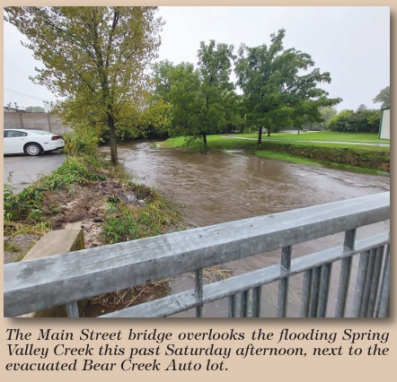
Spring Valley Mayor Justin Mlinar was cautiously walking through downtown Spring Val ley near the Main Street bridge just off Broadway, as evidenced by photos posted to his mayoral Facebook page and submitted to Austin’s KAAL TV of Bear Creek Auto’s lot being far wet ter than is comfortable, water pushing up against the dealer’s south-facing storefront, and Highway 63 almost visible as being underwater, along with other pictures of Broadway between Valley Lanes and the Carnegie Library town hall building and several other
streets awash in unexpected rivers. Minnesota Public Radio (MPR) News relayed on Saturday, “In Spring Valley, Mayor Justin Mlinar reported just after 6:00 a.m. Saturday that all streets were closed due to flooding. Photos posted to social media showed floodwaters flowing along streets in the city’s downtown, near Spring Valley City Hall. Some streets re opened by mid-morning as the floodwaters receded.” Addition ally, MPR News registered that “the Minnesota Department of Transportation (MNDOT) also reported flooding affecting state highways near New Richland and Spring Valley.”
Mlinar, who advised against driving or wading through the flooded streets, posted at 6:00 a.m. Saturday morning, “At this time, all in-town streets have been closed. The water went over the banks early this morning and appears to be holding at this time. However, with the continued chance of rain in the forecast, it could always continue to rise. Please do not drive through water-covered streets/roads. It can be deeper than you think, and erosion could have taken place. If you need to get around the floodwaters, please use the designated routes provided by city, county or state staff.”
Two and a quarter hours later, he wrote, “Floodwaters are slowly receding. However, the streets are still not open for traffic. Please continue to use designated routes provided by city, county or state staff.” And at 10:00 a.m., he was able to post, “The water receded enough that South Broadway is now open. Additional streets will open as the water continues to go down. Please do not ride through the water-covered streets/roads. You don’t know how deep the water is or if there is significant damage to the road.”
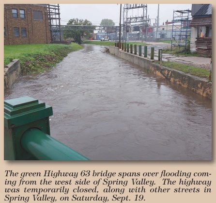
Much later in the day, at ap proximately 4:00 p.m., the creek was still roiling under the Main Street bridge and the Highway 63 bridge north of the Spring Valley Public Utilities power plant, but downtown, the only signs of any flooding having happened were barricades set up against the front of the city hall building, a few sandbags leaning against the repair bay garage door at Bear Creek Auto, and pinecones, grass and other de bris strewn across streets, leaving motorists and pedestrians to only guess how high the sky had fallen that morning.
Courtesy of the Mower County Independent, 135 E Main St. LeRoy, MN 55951, (507)-324-5325


